Extremely mild and wet - both the warmest and wettest yet recorded at this site
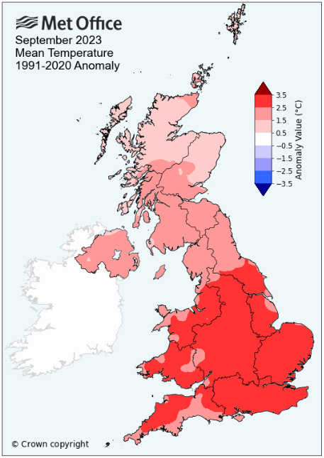
The most striking feature of the season was the great accession of warmth and of its longevity, coming at the beginning of the month and lasting until the 10th, during which the thermometer rose above 77°f on four occasions, one of which went on to top 80°f. Whilst this warmth would subside, the thermometer would remain constantly above the seasonal average for the vast majority of the month and which would ensure that it would close as the warmest September in my records.
However, during this period of warmth, using the official definition of a 'heat-wave' we actually missed out ... most would say a bureaucratic anomaly!
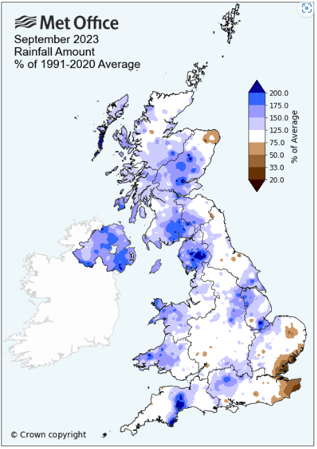
Almost as striking though was the rainfall - after a completely dry first nine days the month then contrived some very large daily totals and would finish well in excess of 200% of the norm' and as the wettest September yet recorded at this site. On two of those very wet days some localised flooding was experienced and this was exacerbated on the 19th with power cuts of several hours.
Apart from the large daily rainfall totals, rainy days became a constant theme and after the dry start to the month there would only be two more dry days during the month as a succession of low pressure systems arrived from the Atlantic to replace the settled conditions found at the beginning of the month.
Whilst the 1st was a cloudy day with weak low pressure (LP) to the SW and an occlusion sat over northern England, the 2nd through to the 9th would see an unprecedented warmth for September as high pressure (HP) would totally dominate and bring us some belated late summer warmth. Indeed the warmth of the days would not have been out of place in either July or August.
The days were simply hot and sunny - following overnight mist the sunshine on the mornings of the 5-8th tended to be a little hazy, but otherwise the days were just sunny. Day-time maxima on the 2nd and 3rd were above 20°c, rising to 24.3°c on the 4th before both of the 5-6th topped 25°c.
However, the 'heat-wave' didn't materialise as the 7th fell just short of the magic 25°c which would have given three consecutive days over 25°c, the official criteria for a heat-wave. However, with the ridge of HP more pronounced over the UK on the 8th, the mercury rose to a month's high of 27.7°c, which in my book of 'non-unofficialdom' constituted a four day heat-wave, especially as it is September after all!
Somewhat curiously, not only wasn't that maximum on the 8th a September record, it also wasn't even the highest ever temperature recorded on the 8th of September in my records! The highest September maximum in my records being 28.5°c from ... the 8th in 2021. Must be something about the 8th!
The 9th would be the last dry day, but it was muggy and warm and now the sun had gone, replaced with cloud and haze. It did however record a remarkably high overnight minimum temperature of 17.7°c (63.9°f), this being the second highest minimum of any day in my records - a new phase in our weather was about to begin ... with a bang!
At 24.1°c the 10th was the last really warm day of the period, but the mugginess of the morning turned to dark brooding skies after lunch and then at 1240h the first bout of a thunderstorm. In the period 1315-40h approximately 21 mm of rain fell, it was torrential. Rain continued through to bout number two at 16h which also contained even heavier rain. The rain finally ceased at 19h, but in this time a whopping 51.5 mm had fallen (63.6 mm fell at Appleby) - this event brought some flooding throughout the county, including nearby at Newbiggin where the 'Eden Animal Rescue' buildings were flooded to a depth of 5" in places.
The heat of the 10th extended overnight into the 11th, which recorded another extremely high overnight minimum temperature of 16.9°c, gaining an entry into my 'top ten', but now the remarkable warm spell was truly over. However, it wasn't the end of the rainfall nor would the 10th sit in isolation as a very wet day!
Just 'bits 'n' bobs' of rain for the next few days, but overnight into the 13th HP built from the SW, giving clear skies which allowed for the temperature to fall away and the first ground frost of the season was recorded.
High pressure would now largely be absent and LP would be the dominant feature, driven across the Atlantic on an active Jet Stream and which also saw the occasional ex-tropical storm feeding itself into the mix. Heavy rain overnight into the 15th saw 18.8 mm credited back to the 14th and this was repeated on the 18th with 18.9 mm credited back to the 17th and with 13.7 mm falling during the 18th itself, the monthly total was quickly racking up ... and then it got worse!
The 19th saw a LP system arrive quickly from the SW, deepening as it approached, bringing windy conditions from the afternoon onwards and then rain in the evening. Late in the evening the winds gusted to 55 Mph and then once into the 20th topped out 56 Mph, but now the rain really got going. That rain was heavy overnight, but became very heavy from 08h and would give a total of 43.4 mm credited back to the 19th. The rain continued through the morning and by late morning there was localised flooding and then the power went off, leaving the whole village with no electricity until 15h. The 20th would only be credited with 7.8 mm and once the fronts had cleared the afternoon soon brightened up.
And the unsettled theme continued for the rest of the month - temperatures fell back closer to the seasonal average, at least by day and even slightly below and rain fell every day, heavily on the 24th and 27th. It seems bizarre to say that the one consolation during this time was that Storm Agnes' 27-28th, wasn't anywhere as bad as forecast and literally fizzled out, albeit we still recorded a gust of 51 Mph.
MSLP of 1012.6 Mb was -2.5 MB below average for the month and overall a mean minimum of 10.75°c and a mean maximum of 18.73°c saw the temperature 2.22°c above the fourteen year average for this site.
It was the warmest September yet recorded at this site - the highest maximum temperature recorded during the month being 27.7°c (81.9°f - 8th), the lowest minimum 3.1°c (37.6°c - 13th).
Rainfall of 213.4 mm (Maulds Meaburn North 220.2 mm -- Castlehowe Scar 281.5 mm) was 243.9% of average for 2007-22, making it by far the wettest September yet recorded at this site (record began 2007) and it was also the 12th wettest of any month in the record.
During the month the following 'days of' were recorded: Thunder on two days -- the wind speed averaged 4.07 mph, with a maximum gust of 56 mph (20th).
We had 0 Air Frosts in the month (year 32) -- Grass Frosts totalled 1 (year 65).
The 1 foot soil temp ranged from a low of 13.8°c on the 30th to a high of 17.8°c on the 9-10th -- with a monthly mean of 15.7°c
The 1 meter soil temp ranged from a low of 13.9°c on the 30th to a high of 15.8°c on the 12th -- with a monthly mean of 15.0°c
This makes the Jan' to September period of 2023 0.91°c warmer than the average for 2009-22 and with 117.8% of average rainfall for 2008-22
At the Met' Office site at Shap a mean minimum of 9.9°c and a mean maximum of 17.9°c saw the monthly mean temperature 2.35°c above average. It was the warmest September yet recorded at the site (commenced 1992).
Rainfall of 298.6 mm represents 227.8% of its average. It was the wettest September yet recorded at the sit (commenced in 1989).
Cumbria Rainfall
A notable proportion of the rain that fell during the month was in the form of thundery downpours, thus making for a rather uneven rainfall distribution across the county.
This was especially true on the 10th when locations in the central and central-eastern portion of the county recorded both large daily totals and fairly extreme falls of 'high intensity of short duration'.
At Dubbs reservoir, which is located 0.85 miles to the NE of Holehird Gardens (Windermere) and SSE of Troutbeck, a fall of 24.2 mm in a 15 min period was recorded; this is a 1 in 348 (or 1 in 395 year event) according to the calculations of the FEH.
That 24.2 mm in 15mins was part of a 45min total of 36.2mm from 1130 to 1200, which is a 1 in 100 year event (1 in 137.61 year event). The rainfall event at Dubbs lasted for 5hrs 45mins for a total of 80.8 mm - a 1 in 116 year event (1 in 156 year).
Using the 'old' definition of intense falls, that 24.2 mm (0.95 inch) at Dubbs falls just short of the classification of 'Very Rare' (1.33 inch of rain in 15mins), its 0.95 inch being classed as 'Remarkable' - the entry category for such falls being 'Worthy of Notice'.
And indeed that 45min total of 36.2 mm more comfortably sits within the 'remarkable' category.
And this followed what was broadly a completely dry first nine days to the month.
However, from the 10th through to the end of the month, rain fell on the majority days and a good number of sites finished with more than double their average for the month. Some of the 24Hr falls on the 10th were large: 90.1 mm at Dubbs Reservoir and 63.6 mm at Appleby In Westmorland, but the falls of 18-19th would be even greater.
Two sites, Honister (117.0 mm) and Greenside Mines (Glenridding)(114.6 mm) would record in excess of 100 mm on the 19th, the former being the largest 24Hr fall anywhere in the UK during September. And that fall at Honister followed on from 61.2 mm the day before (18th).
And so the days continued to be wet and there were further heavy falls on several days, particularly the 24th and 27th.
The largest falls as expressed as a percentage of the LTA, included 247.8% at Burnbanks and 224.6% at Appleby In Westmorland where it was the sixth wettest September in a record that commenced in 1856.
And at some sites in the central-eastern portion of the county recorded excessive falls on several days: Kentmere had 75.5 mm (19th) and 74.4 mm (10th), Burnbanks 79.6 mm (19th) and 64.6 mm (10th), whereas at sites such as Honister, Mickleden and Seathwaite the event on the 10th was far less pronounced and hence why their percentage falls were more in the 150% range.
Yet somewhere in the county always seems to finish relatively dry or at least record less than 100 mm and this time it was Cumwhinton to the SE of Carlisle with 87.0 mm.
Figures from the Environment Agency's rainfall sites were, (figure in brackets being the monthly average for 1991-2020) 'Data kindly provided by the Hydrometry and Telemetry team of the Environment Agency (Penrith)':
At Appleby in Westmorland rainfall of 172.5 mm (LTA of 76.8 mm) represents 224.6% of its average (1856-2022) and made it the wettest since 2000 - since the record commenced, 162 have been drier and five have been wetter.
Haresceugh Castle (Kirkoswald) 124.45 mm -- (84.1 mm)
Brothers Water 424.0 mm -- (214.4 mm) - included a fall of 97.1 mm on the 19th
Seathwaite Farm (Borrowdale) 450.2 mm -- (290.9 mm [average for 1845-2022]) - making it the wettest since 2019 and since 1845 when the record commenced, 156 have been drier and 22 have been wetter.
JANUARY 2010
FEBRUARY 2010
MARCH 2010
APRIL 2010
MAY 2010
JUNE 2010
JULY 2010
AUGUST 2010
SEPTEMBER 2010
OCTOBER 2010
NOVEMBER 2010
DECEMBER 2010
JANUARY 2011
FEBRUARY 2011
MARCH 2011
APRIL 2011
MAY 2011
JUNE 2011
JULY 2011
AUGUST 2011
SEPTEMBER 2011
OCTOBER 2011
NOVEMBER 2011
DECEMBER 2011
JANUARY 2012
FEBRUARY 2012
MARCH 2012
APRIL 2012
MAY 2012
JUNE 2012
JULY 2012
AUGUST 2012
SEPTEMBER 2012
OCTOBER 2012
NOVEMBER 2012
DECEMBER 2012
SUMMER 2012
REVIEW OF 2012
JANUARY 2013
FEBRUARY 2013
MARCH 2013
APRIL 2013
MAY 2013
JUNE 2013
JULY 2013
AUGUST 2013
SEPTEMBER 2013
OCTOBER 2013
NOVEMBER 2013
DECEMBER 2013
REVIEW OF 2013
JANUARY 2014
FEBRUARY 2014
MARCH 2014
APRIL 2014
MAY 2014
JUNE 2014
JULY 2014
AUGUST 2014
SEPTEMBER 2014
OCTOBER 2014
NOVEMBER 2014
DECEMBER 2014
WINTER 2014
REVIEW OF 2014
JANUARY 2015
FEBRUARY 2015
MARCH 2015
APRIL 2015
MAY 2015
JUNE 2015
JULY 2015
AUGUST 2015
SEPTEMBER 2015
OCTOBER 2015
NOVEMBER 2015
DECEMBER 2015
REVIEW OF 2015
JANUARY 2016
FEBRUARY 2016
MARCH 2016
APRIL 2016
MAY 2016
JUNE 2016
JULY 2016
AUGUST 2016
SEPTEMBER 2016
OCTOBER 2016
NOVEMBER 2016
DECEMBER 2016
REVIEW OF 2016
JANUARY 2017
FEBRUARY 2017
MARCH 2017
APRIL 2017
MAY 2017
JUNE 2017
JULY 2017
AUGUST 2017
SEPTEMBER 2017
OCTOBER 2017
NOVEMBER 2017
DECEMBER 2017
REVIEW OF 2017
JANUARY 2018
FEBRUARY 2018
MARCH 2018
APRIL 2018
MAY 2018
JUNE 2018
JULY 2018
AUGUST 2018
SEPTEMBER 2018
OCTOBER 2018
NOVEMBER 2018
DECEMBER 2018
REVIEW OF 2018
JANUARY 2019
FEBRUARY 2019
MARCH 2019
APRIL 2019
MAY 2019
JUNE 2019
JULY 2019
AUGUST 2019
SEPTEMBER 2019
OCTOBER 2019
NOVEMBER 2019
DECEMBER 2019
REVIEW OF 2019
JANUARY 2020
FEBRUARY 2020
MARCH 2020
APRIL 2020
MAY 2020
JUNE 2020
JULY 2020
AUGUST 2020
SEPTEMBER 2020
OCTOBER 2020
NOVEMBER 2020
DECEMBER 2020
REVIEW OF 2020
JANUARY 2021
FEBRUARY 2021
MARCH 2021
APRIL 2021
MAY 2021
JUNE 2021
JULY 2021
AUGUST 2021
SEPTEMBER 2021
OCTOBER 2021
NOVEMBER 2021
DECEMBER 2021
REVIEW OF 2021
JANUARY 2022
FEBRUARY 2022
MARCH 2022
APRIL 2022
MAY 2022
JUNE 2022
JULY 2022
AUGUST 2022
SEPTEMBER 2022
OCTOBER 2022
NOVEMBER 2022
DECEMBER 2022
REVIEW OF 2022
JANUARY 2023
FEBRUARY 2023
MARCH 2023
APRIL 2023
MAY 2023
JUNE 2023
JULY 2023
AUGUST 2023
OTHER ARTICLES
The Oldest Inhabitant
An Inch Of Scotch Mist
But it's meant to be Summer (Summer 2017)
© Darren Rogers 2010-23
Want to comment on this site? email